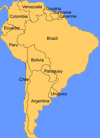
Buenos Aires – It’s a rainy day today, so I’ll go with a second post that’s been in the works for awhile. A few weeks back I did an early Saturday morning introduction to the geography of Uruguay, and have realized that I’ve never done the same for Argentina. This has been underscored recently by series of e-mails with friends, readers, and clients, who seem to be under the impression that Argentina is some little dot of a country, somewhere down there (vague hand wave in a southerly direction). I honestly don’t mean this to be condescending, so for those of you who take some of the following information for granted, please don’t take it that way. I’m responding to actual misconceptions on the part of folk I’ve corresponded with in various parts of the world. Let’s narrow it down bit by bit. First, Argentina is in South America. Not Africa (similar shape, different continent). Not Australia. It’s not the capital of Brasil. Nor Venezuela. [Thanks to all the various websites from which I’ve lifted the following maps.]
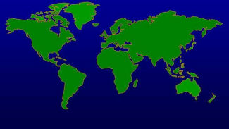
And, South America is south and EAST of North America. I’m not sure why, but most folks (including some here) seem to think it’s either straight south, or actually west. That means, that at least at this time of year (daylight savings time changes and all that), in Buenos Aires it’s an hour later than in New York (the other half of the year it’s a two-hour difference). Note also that it’s in the southern hemisphere of the planet. Beyond important considerations such as whether water goes down the drain in the opposite circular direction (it does), the seasons are flipped by half a year from the northern hemisphere. When it’s winter there, it’s summer here, etc. Right now, we’re in early fall, the leaves are turning colors, the weather, some days, has a bit of a snap to it, and it rains a bit more than usual.
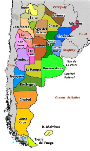
On to Argentina itself, and this colorful display of its 23 provinces. Yes, it’s big enough for 23 provinces (plus the autonomous Capital Federal district), at 2,360 miles north to south and 884 east to west. In fact, it’s just under 30% of the size of the United States. As a rough, though not exactly accurate guide, think most of the continental United States east of the Mississippi River. For Canadians, think of the entire east – Ontario, Quebec, New Brunswick, Newfoundland, and Nova Scotia. For Australians, think Queensland, New South Wales, and Victoria all rolled into one. I don’t even want to try to figure out a European comparison – a lot of your countries all bundled up together… Okay, I’ll give you one just to give you some perspective… See the province of Buenos Aires in that parrot green color? That province, and the country of Poland, are basically the same size. All of the UK would fit very comfortably inside the province, with room for most of Ireland. All of that, by the way, doesn’t include the fact that Argentina “owns” nearly 375,000 square miles of the continent of Antartica. So, for those planning out their tour itineraries; no, in a long weekend, you don’t have time to see the Iguazu Falls in Misiones, Mendozan wineries in the west, the glaciers of Tierra del Fuego in the south, and wind up back here in the city for a café cortado after lunch.
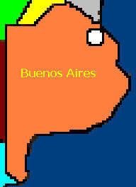
Just to show where the city (the autonomous federal district) of Buenos Aires is, it’s basically the white circle in this map of the province. The province as a whole has around 15 million people in it. The area usually referred to as Gran Buenos Aires, which includes 24 surrounding suburbs, has 13 million of those. Within city limits proper, we’re looking at somewhere just over 3 million.
And that brings us to the city of Buenos Aires – originally Ciudad de la SantÃsima Trinidad y Puerto de Santa MarÃa de los Buenos Aires, City of the Holy Trinity and Port of Saint Mary of the Fair Winds. At just over 77 square miles of surface area it’s not a small city – not huge, but not small. As mentioned, roughly 3 million people live here. The city is divided into 47 barrios, or neighborhoods, each of which has a fairly distinctive character, much like the various neighborhoods of many a metropolitan city. The colorful areas along the eastern part of the city map are the areas that most tourists see, and many probably don’t see all of those, limiting their explorations to Recoleta, Palermo, San Telmo, and Puerto Madero. I live in a subsection of Recoleta, along it’s border with Palermo, usually referred to as Barrio Norte, though it’s not a separate barrio.
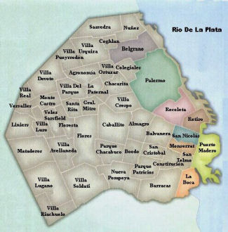
Oh, and back to those misconceptions… Buenos Aires, if you look at the maps, is on the Rio de la Plata, a river. We’re not on the ocean, we don’t have beaches. You might be thinking about Rio de Janeiro – that’s in Brasil. Beaches are south and east of here – for the most part, for good beach communities, you’re looking at anywhere from 2-4 hours away.
Wow. Great overview of Argentina!
Nice geography lesson! Thanks!
Paz